If, as a newcomer, you had walked up the right-hand side of Hurst Park Avenue from Milton Road in March 1957, you would first have noted Hurst, the impressive Victorian house across the road. Continuing up past the garden fence of 95 Milton Road, longer than it is now as no dental surgery stood on that land, you would pass the flat-roofed art deco houses at numbers 2 and 4, and then five red-brick, metal-windowed houses at 6 to 14. You might have been struck by the contrast in house-building styles between odd- and even-numbered sides of the road.
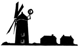
But what you would find next might be a surprise: a plot of mostly open land, with out-buildings, an old cottage and the derelict tower of a windmill. This mill, just over 100 years old, was the last of a line that had stood on the site for over 350 years. By the end of April it had gone, but the 1930 photograph near the end of this section will help you imagine it where the houses at numbers 24 and 26 stand today. That location is confirmed by the National Library of Scotland’s web page where a modern satellite view is overlaid by the 1901 Ordnance Survey. 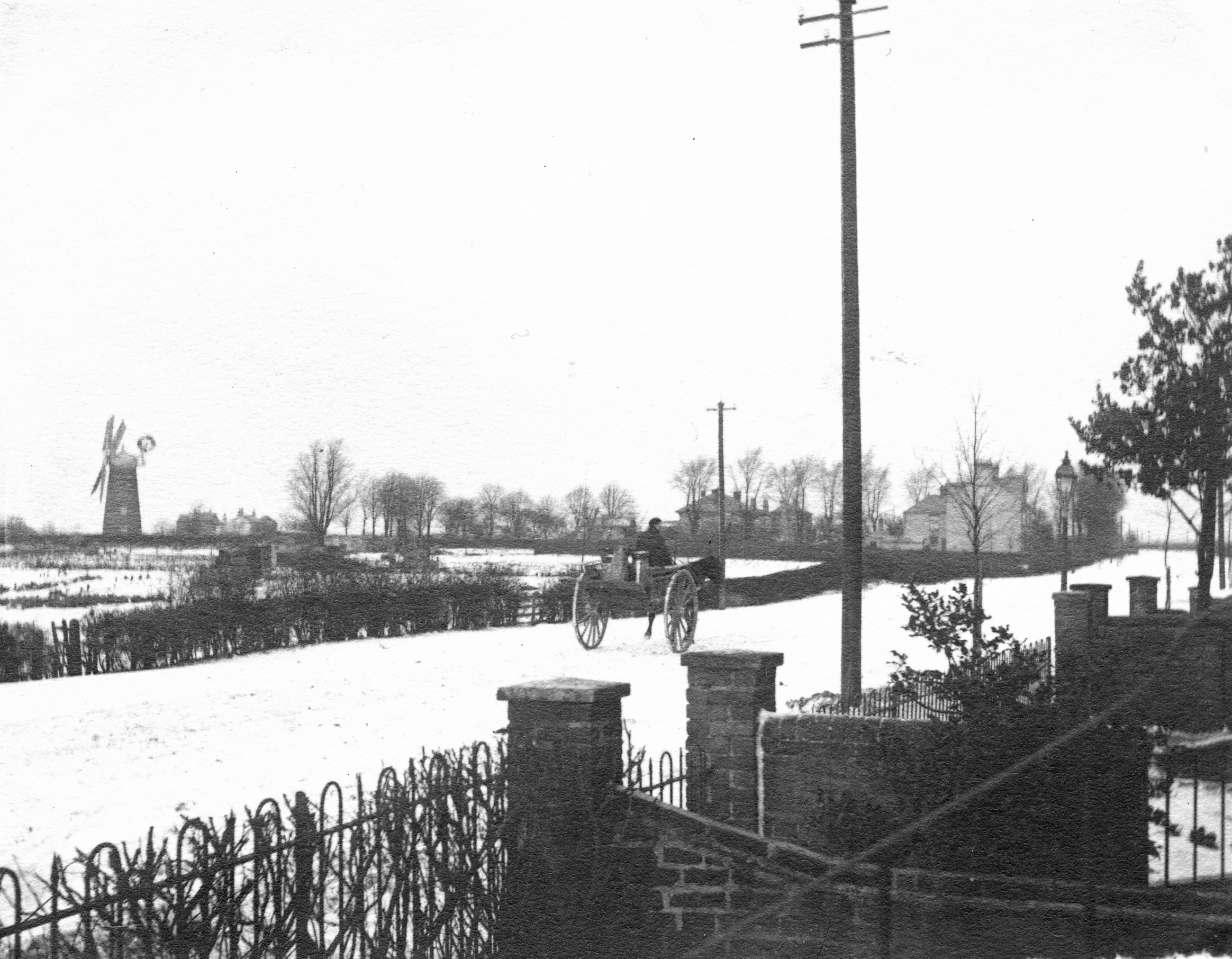
A view of the mill, from Milton Road near the present-day junction with Gilbert Road, in about 1900. Hurst is just above the horse’s head; the Limes is visible between the pole and the street lamp. This appears to have been taken on the same day as the two pictures that illustrate our pre-1927 section (Cambridgeshire Collection, Cambridge Central Library).
Peter Filby, in The Windmills of Chesterton (Chesterton Local History Group Journal No. 9, December 1992, pp 7-10), tells us that the Chesterton Manor Windmill had been on a different site, in Middle Field, north-east of Arbury Road. What we know as Union Lane had led towards that mill and was called Mill Lane or Mill Way. However, by the end of the sixteenth century, milling had moved from there to Clayton Way, a track that left the road to Ely close to where the bottom of Highworth Avenue is now. Clayton Way led west across the fields to Histon Road, its route marked on the Chesterton enclosure map.
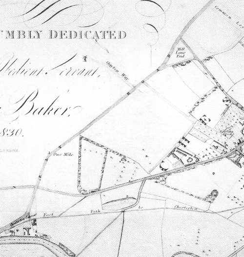
Baker’s 1830 map of Cambridge. The mill is shown by Clayton Way (Cambridgeshire Records Society, 1999)
The mill and Clayton Way are shown on a number of maps, including Baker’s 1830 survey of Cambridge, published three years after a new smock mill on the site had been built by local farmer Thomas Riddel, whose name appears clearly on the Enclosure map. Clayton Way was “discontinued and stopped up” in the enclosure of 1839, under “An Act for inclosing lands in the Parish of Chesterton, in the county of Cambridge” (Cambridge Chronicle and Journal, January 1839).
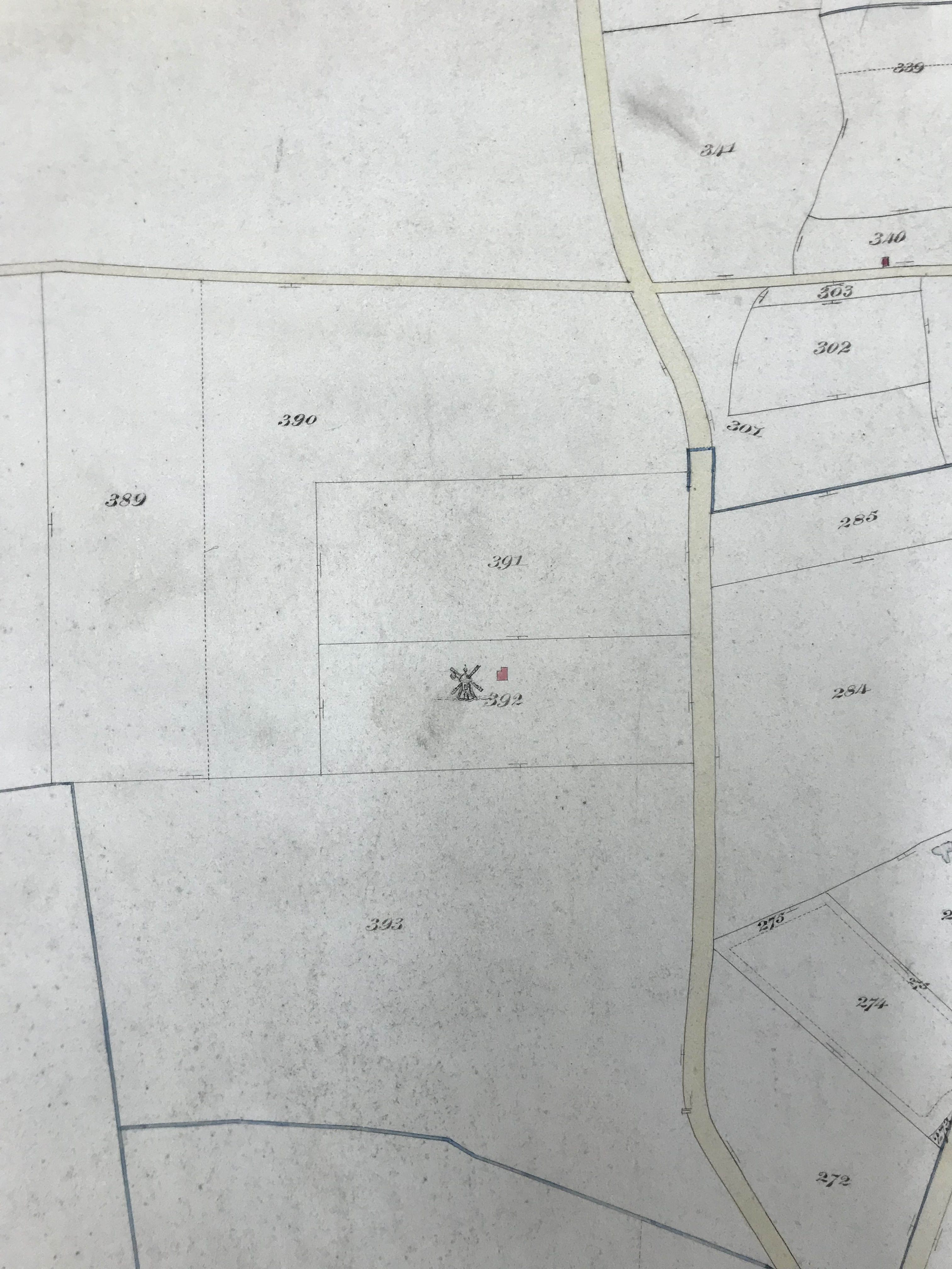
The mill shown north of Milton Road on a post-enclosure map of 1840. Clayton Way, no longer marked, was “stopped up” by the recent enclosure. (For orientation the road running horizontally across the top, from the left, is Arbury Road over Milton Road and into Union Lane.)
An earlier smock mill had been built on the site in 1730 for Cambridge bakers Uriah Matthews and William Anderson. This was demolished in 1809, and Riddel’s mill was not long-built in 1827, Filby tells us, “when it was tail-winded and two sails were blown off” on November 2. The Cambridge Chronicle of November 9 has a graphic description:
Late on Friday night last the village of Chesterton, near this town, was visited by a violent hurricane. In its course two sails of the mill recently erected near the village were blown off; it then passed over the premises belonging to Mr W Wragg, where the garden fence and a hovel were blown down, a barn untiled, and thatch of several stacks covered the ground for 200 yards.
Sixteen years later, there appears to have been another new mill, then advertised to let by Thomas Riddel:
Cambridge Independent Press, 9 December 1843
Henry Mann bought this mill in 1847, probably from James and John Riddle (spelt thus) who were probably Thomas Riddel’s executors. Our circumstantial evidence for that is contained in sales particulars for Hurst dated 1885. That document refers to a sale by the two Riddles of the land that Ely Villa / Hurst was built on, to John Jones on August 24, 1847. It seems reasonable to suggest that they were Thomas Riddel’s trustees, disposing of his estate, and we assume that they sold the windmill to Mann at about the same time that they sold some of the rest of the plot to Jones, who built Ely Villa there.
Having worked the mill for eight years Mann was lucky to escape a fire that destroyed it in the early hours of May 14, 1855.
CHESTERTON. Fire. On Saturday morning a flour mill, at Chesterton, near Cambridge, the property of Mr. Mann, miller, was destroyed by fire. It appears that about three o’clock in the morning Mr. Mann and his son were both working at the mill, and suddenly they found themselves enveloped in flames and smoke; they just managed to escape, and in half an hour the mill was burnt to the ground. The cause of the calamity is unknown, but it is supposed that a candle left burning below had ignited some sacks, and hence the disaster.
(Cambridge Independent Press, May 1855)
Happily, Mann was insured for £700 and opened a brick-built tower mill in October 1856. According to the Mills Archive, his new mill was probably built by John Whitmore, a millwright and engineer from Wickham Market in Suffolk. A number of Whitmore mills remain in East Anglia.
On December 6, 1856 Mann advertised in the Cambridge Chronicle and University Journal for “a Journeyman MILLER who can make himself generally useful” who was “WANTED immediately.
Mann traded with his brother Edward, but their partnership was dissolved in March 1860 with the announcement that “All debts due to, or owing by, the said Firm, will be received and paid by the said HENRY MANN, who will in future carry on the business”. (The Cambridge Independent Press, March 31st 1860). Henry, Peter Filby tells us, struggled to pay the mortgage and the mill was for sale by August that year.
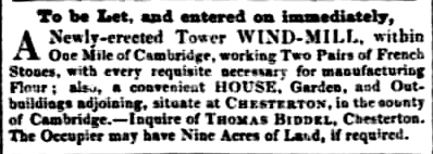
The sales particulars for the auction on August 18th 1860 make interesting reading. The mill was said to contain:
Six Stories [sic]; with Patent sails, and a Fan tail, driving Two Pairs of French Stones, with a spare runner; to which has been added, within the last twelve months, at a heavy expense, a very valuable ten-horse-power portable steam engine (Cambridge University Library).
The “heavy expense” cannot have helped Mann’s financial position, but we learn from this document that the mill no longer depended on wind power alone. We are told, too, that among the facilities at the commodious Mill House were two kitchens, four bedrooms, garden, stable, piggeries and “two good wells”. The last appear as pumps on later Ordnance Survey maps. The three-acre plot of land was “abutting upon the Turnpike Road” (the road to Ely, now Milton Road) and was “admirably adapted for Building Purposes.” This last suggestion was not taken up until about 50 years later when houses were built facing Milton Road. Development of the whole plot would not be completed for nearly a century.
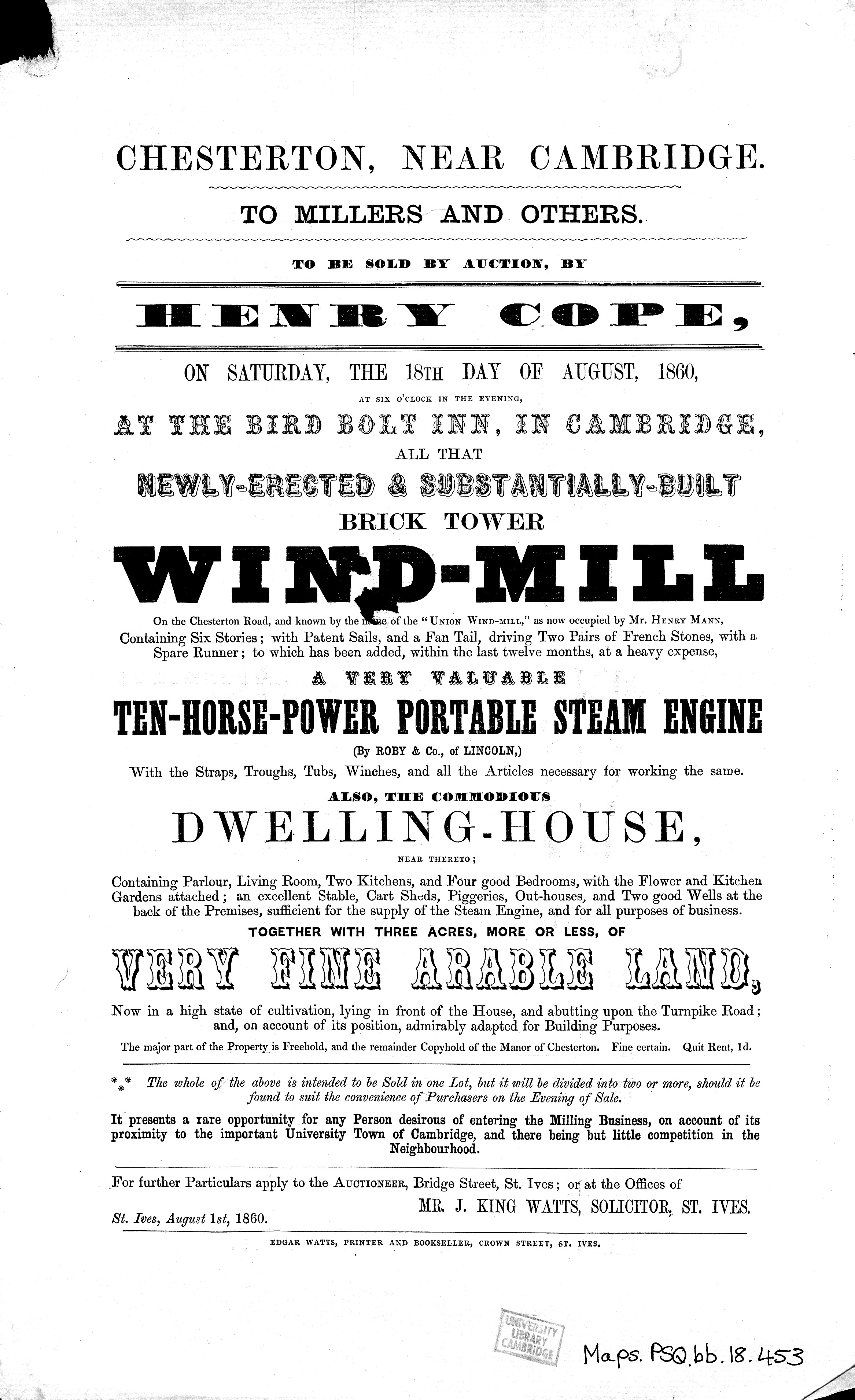
The 1860 sale notice (Cambridge University Library)
Inevitably in a sale document, there was an optimistic view of business prospects that was perhaps belied by Mann’s situation: “It presents a rare opportunity for any Person desirous of entering the Milling Business, on account of its proximity to the important University Town of Cambridge, and there being but little competition in the Neighbourhood”. The auction was to be at the Bird Bolt Inn. That the mill is referred to as ‘The Union Windmill’ probably refers to its being owned, in effect, by a group of Mann’s creditors. Other Union mills were owned by consortia or sometimes by creditors.
As things turned out, it was a competitor who bought it, but not until 1862, and the 1861 census shows us that Mann remained there in the meantime, despite the Cambridge Independent Press of February 2nd 1861 announcing that he was declared bankrupt on January 25.
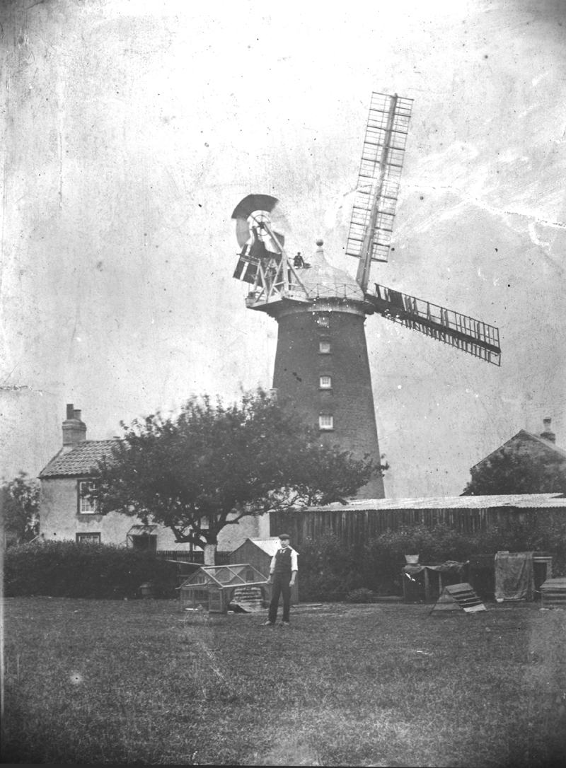
The mill in about 1900. A cutting from the Cambridge Daily News, July 19 1958, tells us that it is William Baker standing on top of the mill (the Mills Archive).
Peter Filby tells us that the mill, on its ‘three acres, more or less’ was bought in 1862 by William French, who owned Chesterton Mill, which stands today in French’s Road, off Victoria Road. From documents for one of the houses facing Milton Road, we learn that William French and solicitors Frederic Barlow and John King Watts sold just over two and a half acres of this land to carpenter Peter Fulcher on August 13, 1862. Fulcher then sold all but 11 poles to John Jones of Ely Villa on December 30, 1865 for £500. The original conveyance of that date came to our attention in a bundle of documents from a house in Hurst Park Avenue in April 2022.
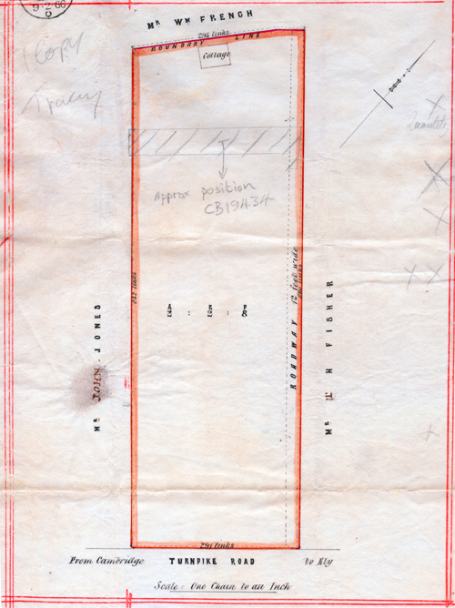
The original 1865 conveyance documentfrom Fulcher to Jones came to light in a bundle from Hurst Park Avenue that was lent to us in April 2022. This is the plan from that document. The conveyance bears John Jones’s signature, which we have included in our section on Hurst.
French died in March 1901 and his wife Rebecca in October 1902. The mill was advertised for sale again, along with its “brick and tiled cottage”, “timber and tiled stable” and “fertile gardens”, this time on the much smaller plot of land, 1 rood and 25 poles, retained in 1862. Eleven poles were freehold, the rest copyhold.
Peter Filby speculates that William Baker, French’s last miller, may have bought the mill or worked for somebody else. He is listed as “Miller, retired” living in Mill House in the 1911 census, having also been there ten years earlier. However, we know from an abstract of title to one of the newer houses nearby in Hurst Park Avenue that butcher Arthur Rose bought the land from French’s executors, his son George and son-in-law Edwin Burrell. We learn from the Cambridge Daily News, 25 July 1912, p 2 (the day of his funeral), that Baker had died and was buried in Histon Road cemetery.
George French and Edwin Burrell were “admitted tenants to the said piece of [copyhold] land, Windmill and premises described”, except the 11 poles to which they already owned the freehold, on May 6, 1902. On June 12, 1903 their copyhold was enfranchised (converted to freehold) at a cost of £19 13s 9d paid to the owners of the manor of Chesterton. Eight days later the combined freehold plot of 1 rood and 25 poles was conveyed to Arthur Rose for £215. Rose and William Baker, his under-tenant, were already in occupation.
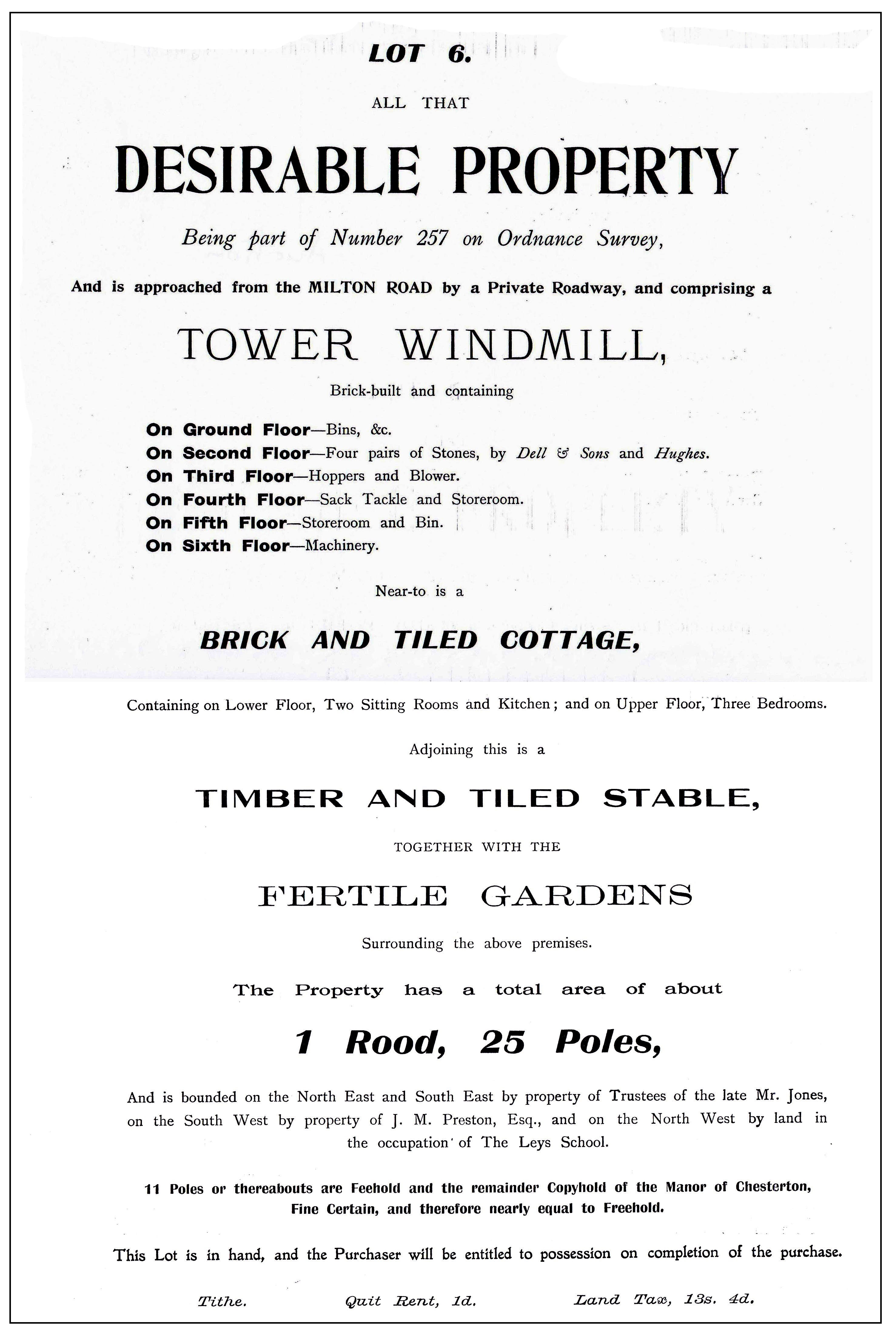
The mill described in the sales particulars in 1903 (Cambridgeshire Archives)
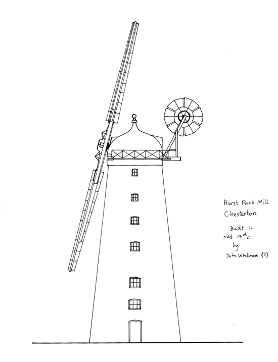
Peter Dolman (1955-2002) was a quantity surveyor, mill enthusiast, millwright and miller who was an expert on the mills of East Anglia. He produced many drawings, including this one of the Union Mill (the Mills Archive).
As for the people living and working there over the years a number of general and journeyman millers are listed in censuses, though not always in specified dwellings. Stephen and Elisabeth Riddle appear in 1841 while Mann and his family are there in 1851 and 1861. Others, presumably French’s employees, include Richard Twinn (1871), Philip Thulbone (1881) and Isaac Everett and Robert Fuller (1891). Spalding’s Directory in 1887 lists Frederick Hawkes, cattle dealer, in Mill Cottage and miller John Watts; in 1891 Spalding tersely lists Everett in the cottage and Tebbitt at the mill.
There is some confusion about the dwellings on the site. The 1860 sale document discussed above refers to the “commodious Mill House.” The 1901 census refers to Mill House, occupied by land agent Edmund Burton and his wife Sarah. In the same census Baker is shown resident at French’s Mill House, with his wife Emma and three children. Close scrutiny of the photograph at the beginning of this section shows two substantial buildings next to the mill. In 1911 we find the Bakers listed at Mill House (in four rooms). Mill Cottage (six rooms) is occupied by William Blackwell, a butcher’s horse-keeper and groom, with his wife Emma, three children and his mother Elizabeth. Blackwell was obviously employed by Rose, who is listed as occupying his nearby slaughterhouse.
Decline seems to have set in after William Baker died, and Peter Filby tells us that milling was restricted during the First World War. The sails were removed in 1920, the photograph below showing it as a re-roofed shell used for storage by Stanley Rose. He had taken over the family’s butchery business, including the slaughterhouse by the mill when his father Arthur died suddenly on November 16, 1914. Their shops were in Peas Hill and Petty Cury. Mrs Baker is still there in the 1913 street directory, with Blackwell in the cottage. His domain would have been the stable and the paddock, the land from about 14 Hurst Park Avenue down to the boundary of the modern dental surgery and the garden-ends of 97 and 99 Milton Road.
Arthur Rose established his slaughterhouse next to the mill. This advertisement is from the Cambridge Chronicle of December 12, 1913. He died in November the following year, leaving the business to wife Etheldra and son Stanley.
This brings us to yet more land transfers. In 1911 Arthur Rose had bought that part of Riddel’s land which we can imagine as bounded by Milton Road to the south-east, the back-garden boundaries of Highworth Avenue to the north-east, the pavement of the even-numbered side of Hurst Park Avenue to the south-west and the windmill plot he he had owned since 1903 to the north-west. On January 21, 1911 Rose paid £650 to the executors of John Jones whose last surviving daughter had died on May 16, 1910. What he bought was 2 acres, 2 roods and 4 poles, with cottage, outbuildings and yard and we learn from an abstract of title that he was already in possession, presumably renting it. This piece had been measured at 2 acres, 2 roods and 8 poles on the occasions of previous transfers.
The same abstract of title that provides all that information also records a pre-contract agreement for Rose to sell the Milton Road frontage (all the land of numbers 95 to 99 and the dental surgery) to William Pushee Hollis of Chesterton Road, Councillor for North Chesterton. Numbers 97 and 99 Milton Road were built by 1913 and 95 some time later. Rose retained the right of access to the mill and slaughterhouse via the lane on the north-east boundary of this plot. This right would have been established when Clayton Way was stopped up in 1839.
Later on, in 1935, William Rawlinson is listed as living at Mill House and may still have been there in 1957. Yet later he is shown at 16 Hurst Park Avenue, the new house that Stanley Rose retained when the land was developed between 1957 and 1961 and which is called The Mill House on sales particulars from the early 1960s.
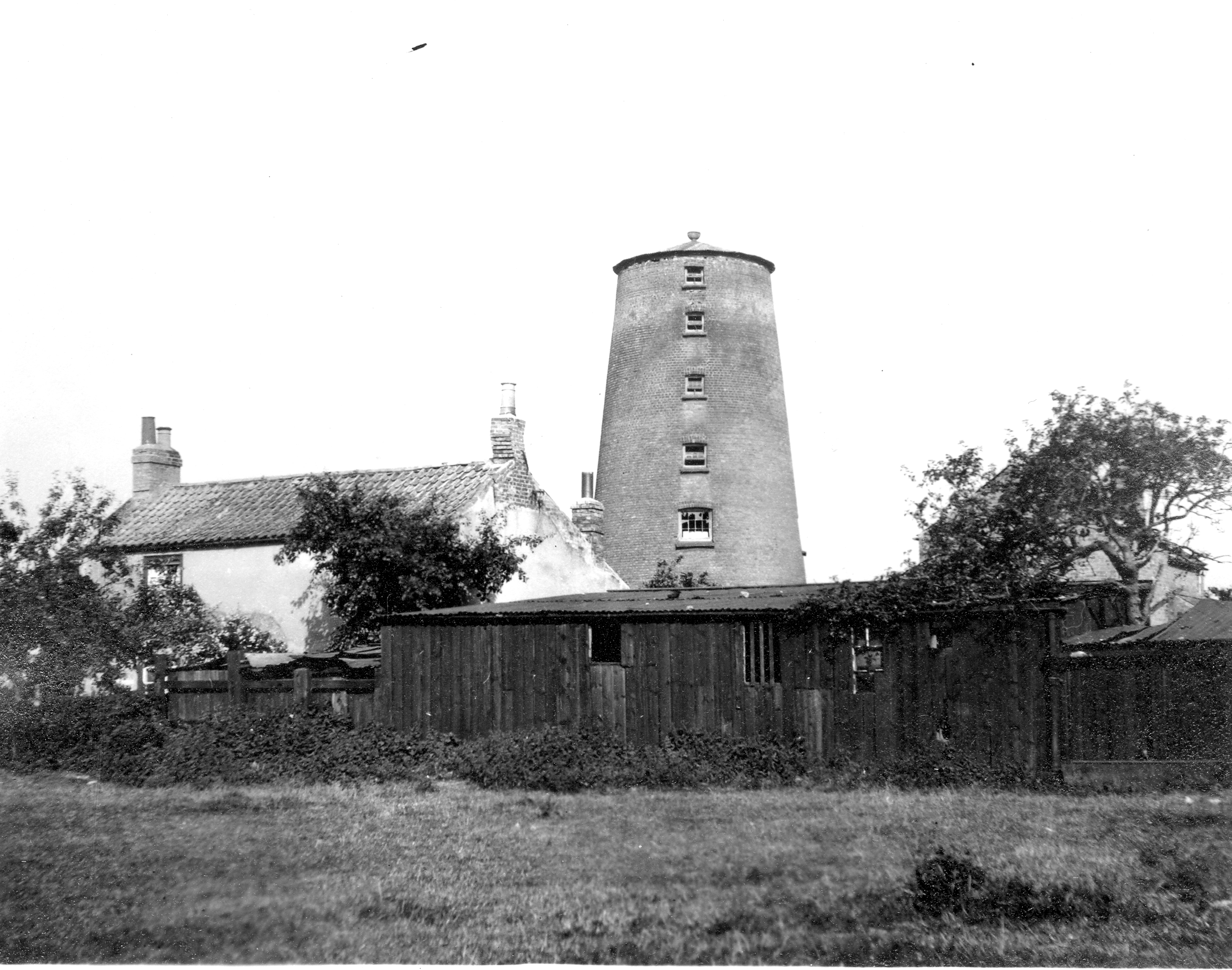
The mill and cottage, probably contemporaneous with the next picture, from the same angle as the 1900 picture displayed further above (Cambridgeshire Collection, Cambridge Central Library)
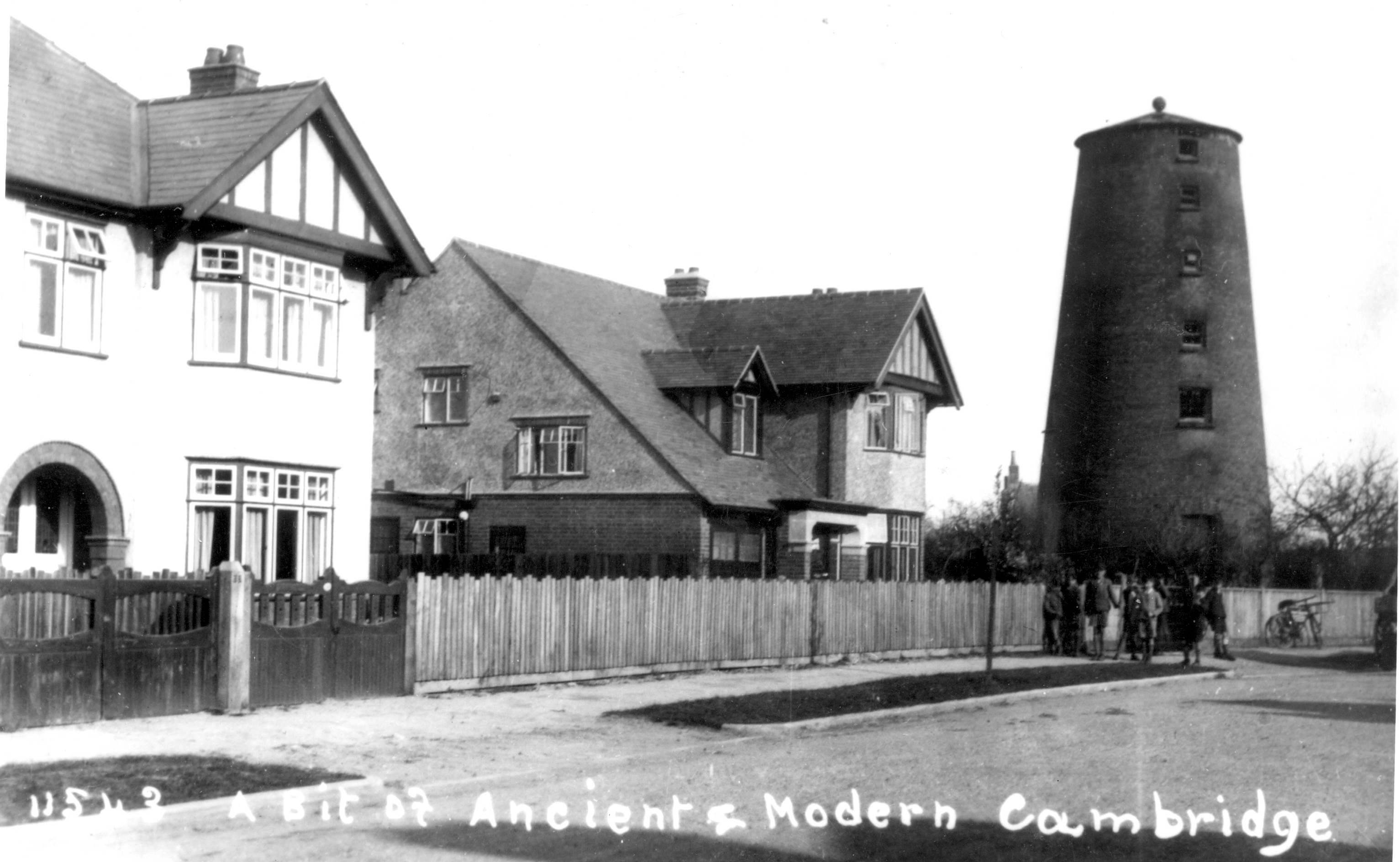
The re-roofed tower mill in use as a store in its new setting, Hurst Park Avenue, in 1930. Next to it, number 32 was built for George Heath, managing director of the Eaden Lilley department store and helps locate the mill at what is now number 24 (Cambridgeshire Collection, Cambridge Central Library).
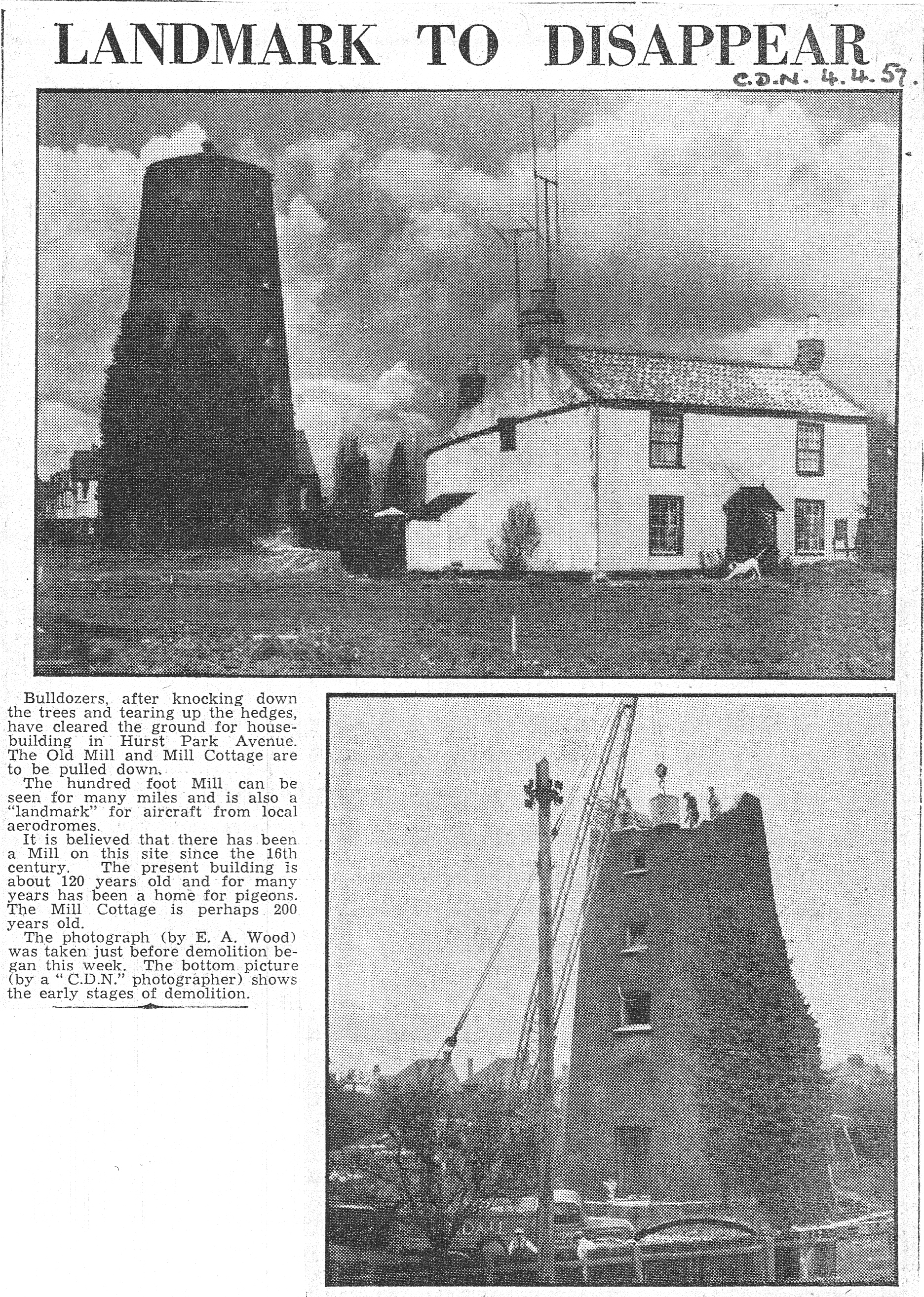
Finally the Cambridge Daily News (April 4, 1957) reported the demolition of the mill and Mill Cottage which was “perhaps 200 years old”. Numbers 16 to 26 Hurst Park Avenue were built on the site by Sindall, whose demolition lorry can be seen in the photograph below.
(Cambridgeshire Collection, Cambridge Central Library)
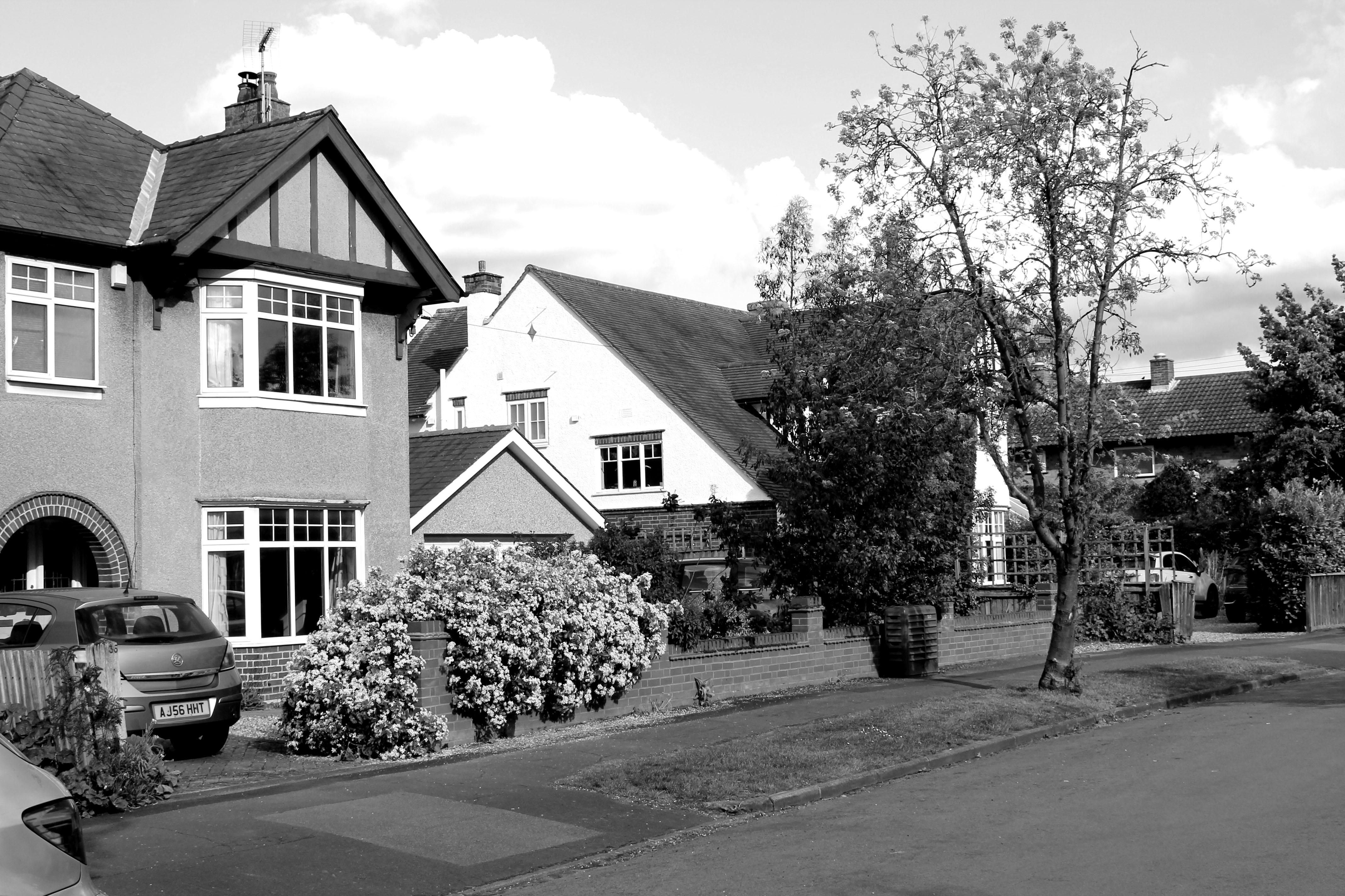
This Hurst Park Avenue scene was taken from the same position as the 1930 photograph above on May 1, 2020. Number 24 has replaced the mill.