The land in 1840
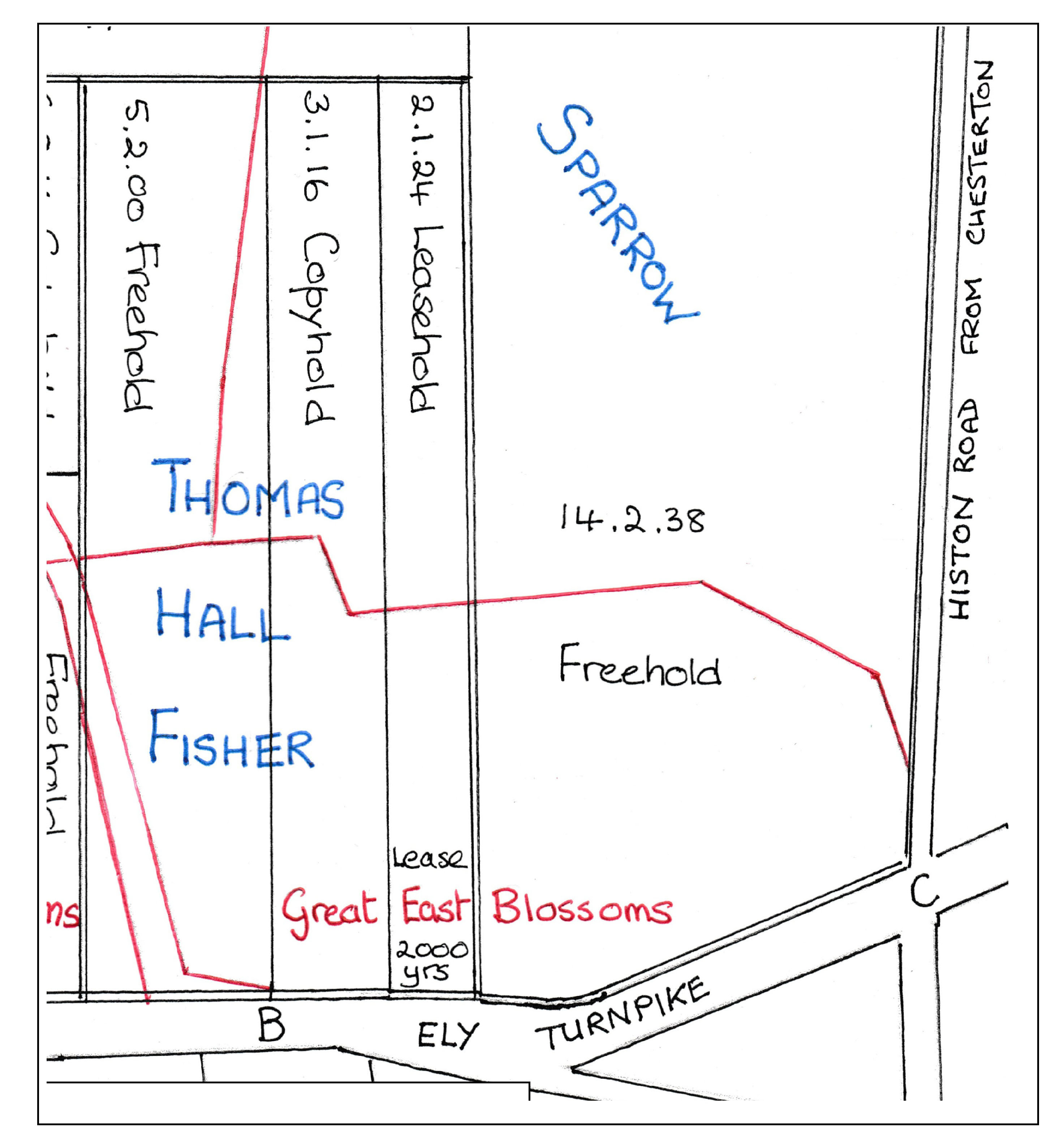
The plan below (our tracing and adaptation from the Enclosure map held in the University of Cambridge Library) shows how the land was allocated at enclosure in 1840. Both Thomas Hall Fisher and Robert Sparrow had extensive holdings in Chesterton. Pre-enclosure field boundaries and Clayton Way are marked in red. Point B marks the modern junction of Milton Road and Highworth Avenue, the latter being built straight up the middle of Fisher’s land after 1912. Fisher’s holding is here shown divided into its freehold, copyhold and leasehold plots, different forms of land tenure which are defined in our section on Chesterton before 1927.
Leys Road was built east-west across Sparrow’s land, its alignment becoming clearer in the next plan, dated 1852.
1852 onward: the land is bought and sold
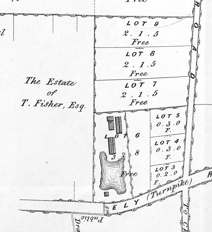
Robert Sparrow’s land was advertised for sale in 1852. Sparrow died in 1847 and his wife Tabitha in November 1851: their trustees sold the land after her death. Lots 8 and 9 are the future site of Leys Road and some houses in Arbury Road; the brickfield on lot 6 (where Mulberry Close is now) later expanded onto lot 7.
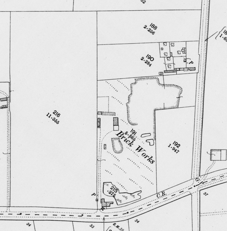
The 1901 Ordnance Survey map. John Jones, the owner of Ely Villa (later Hurst), bought Fisher’s land (plot 216) in 1866 and died in 1878. It remained his trustees’ responsibility until they sold it in 1911, after the last of his daughters died in 1910. Plot 216 was still divided into its freehold, copyhold and leasehold parts. Leys Road would be laid out on plots 188 and 190 in 1912.
Other than presuming that this was when the Roe family bought what was later Leys Farm and Laundry, just to the north, we do not know who bought the Sparrows’ land in 1852 but we learn from the documents for 20 Leys Road that in 1907 John Thomas Fulcher owned plot 190 on the 1901 OS map. Plot 188, documents for 21 Leys Road tell us, was owned in October 1911 by Leys School, who occupied the adjacent farm and laundry. The school had only bought plot 188 on December 9, 1910 from Ellen Sarah Perry and the Rev Samuel John Sherbrooke Banks.
In contrast, we have a complete picture of the ownership of the Highworth Estate land: we even know a little about who occupied it in 1582. The western end of Leys Road is on plot 216 on the 1901 map and the documents for house number 3 tell the story after 1840. As we have seen, Thomas Hall Fisher occupied 11 acres and 1 rood: 5 acres and 2 roods were freehold; 3 acres, 1 rood 16 poles were copyhold from the Manor of Chesterton; and 2 acres, 1 rood and 24 poles were leasehold.
Thomas Hall Fisher, born 1789, is listed in the 1851 and 1861 censuses living in Petty Cury, Cambridge. He was a banker. The Chesterton enclosure map shows that with George Fisher he also held about 7½ acres north of the river Cam near Jesus lock. The land included the brickfields that were in the area now between Carlyle Road and Hertford Street and including Alexandra Gardens. Fisher Street runs from Victoria Road to Alexandra Gardens.
The Enclosure map and register, and the house documents, all agree that the lease on the smallest piece was for 2,000 years. Documents for 3 Leys Road tell us that this 2,000-year lease was created between Thomas Brackyn and Robert Beaumonde, and was dated November 25 in the twenty-fifth year of the reign of Queen Elizabeth (1582). In 1911 it still had 1,671 years to run, at an annual rent of 2d. Before we get there, however, we must go back to 1866, when Fisher sold the land.
John Jones bought the combined 11¼ acres, then occupied by Thomas Keath, from Fisher on September 29, 1866.
Thomas Keath was born in 1803. In the censuses of 1851, 1861 and 1871 he is described successively as farmer and hay factor, farmer and inn keeper, and hay factor and publican. On the last two occasions his address is given as the Haymakers Inn, Chesterton High Street; in 1851 it was ‘public house’ in the High Street.
Jones paid £1,000 to Fisher, who covenanted that he had good right to convey the land: that may have been true, but he should have surrendered his copyhold tenancy to the Manor of Chesterton, when the Lord of the Manor would have reassigned it to Jones. The lease could have been transferred then, too. Nobody noticed that until after Fisher’s death on September 21, 1867. Jones applied to perfect his title to the two smaller plots once Fisher’s will was proved on December 11.
The matter was not resolved for three years. On February 20, 1871 Fisher’s executors covenanted with Jones to have themselves admitted as tenant of the copyhold, to immediately surrender it to the Lord of the Manor and also to transfer the leasehold tenancy to him. They became the tenants of the copyhold on the following day. On March 4, Jones paid them five shillings and they duly surrendered the copyhold to the Manor. Jones was admitted tenant on March 6 and the annual rent remained as it had been: 3s 9d. It is not clear when the leasehold plot was transferred but we assume it was around the same time.
We know from references to Jones’s will that his executors were to collect rents and divide the proceeds between his wife Sarah and daughters Elizabeth and Sarah. Jones died on January 20, 1878 and his executors were admitted tenant to the copyhold on October 23.
1911 onward: the roads are developed
The last of Jones’s daughters died in 1910. On February 18, 1911 his executors sold all the land to Rev George Richard Frampton of Highworth, Cambridge Road, Great Shelford for £1,580, divided for stamp duty as £1,150 for the freehold and leasehold and £430 for the copyhold. Frampton’s father was born in Highworth, Wiltshire. The whole plot was occupied by Alfred Rose, the butcher-cum-mill-owner. Frampton was admitted tenant of the copyhold on March 27, 1911. On May 22, 1911 he paid £29 18s 11d to have the plot enfranchised. On March 24 he had been assigned the leasehold land and the term of 2,000 years was enlarged into a fee simple (freehold): the 11¼ acres now formed a single freehold plot.
Meanwhile, Frampton wrote to the Cambridge Daily News (14 March 1911, p 4) making the case for public funding of sewers to serve Highworth Avenue and Leys Road (despite the heading provided by the CDN).
Frampton, 54 in 1911, was clearly a man of action and did not hang around. On April 18, 1911 he sold the south-western corner of the plot, with a frontage of 50 feet to Milton Road and a depth of 220 feet, to Peter Arthur Stevenson, tailor, of Burleigh Street. That is now 101 Milton Road. No price is recorded. Then, on July 31, he sold the rest to James Albert Wootten, of 17 Lyndwode Road, Cambridge, gentleman, for £2,050. We presume he departed with a few hundred pounds profit and bequeathed the name of his house in Shelford, where, according to the 1911 census, he lived with his 30-year-old wife Martha. They had married in 1896 and by 1911 had ten children, the youngest being one year old. We infer from the 1939 register, when family members were farming in Sawston, that another was born in 1912.
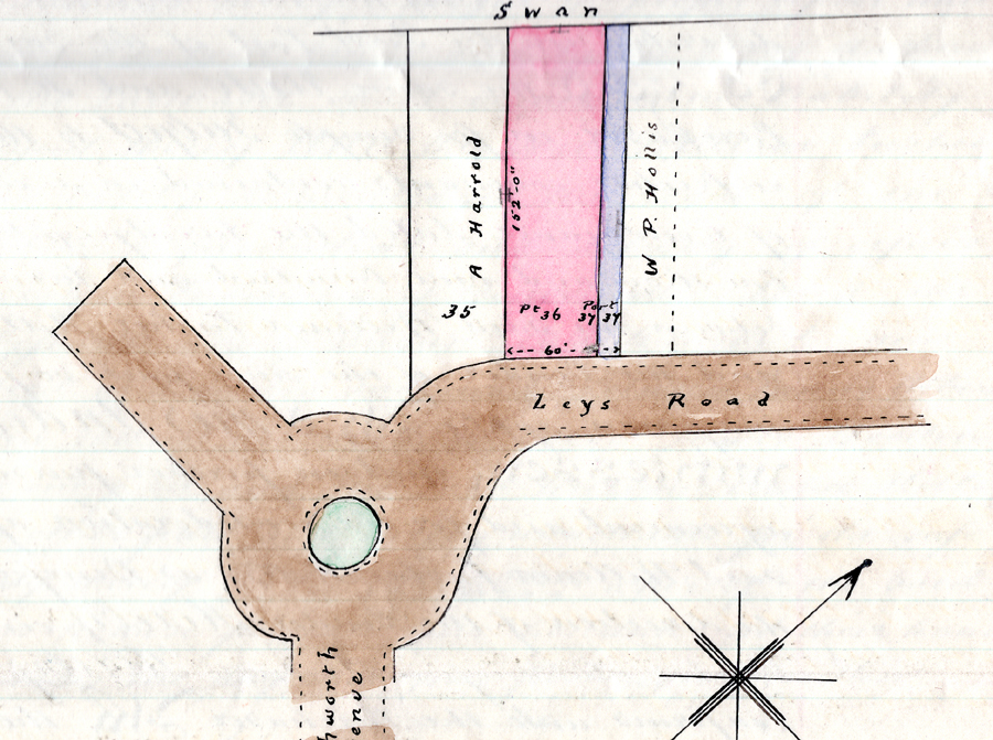
The eastern end of plot 190, from Wootten’s Highworth Estate plan of 1912, with houses facing Arbury Road in front of the plot later occupied by Jude’s garage and then Austin Court. There is the remnant of an orchard, which is shown to have been much bigger on the 1885 Ordnance Survey map. One of the pair of houses there still bears its pseudo-Latin motto, arboreta florent domus.

This is Hollis’s 1912 plan of the same plot, which he had owned since 1907 and which had already acquired a new house facing Arbury Road at the proposed Leys Road corner. There have been changes to the outbuildings, too.
In the meantime, William Pushee Hollis, Turf Accountant, of New Burlington House, Chesterton Road had bought plots 190 and 192 for £1,450 from Fulcher on August 31, 1907. What he bought, according to documents from 20 Leys Road, was:
Firstly All that piece or parcel of land or ground situate lying and being in Arbury Road (then formerly called Awberry Road) having a frontage to the said road of 173 feet … and containing 2 acres 1 rood and 5 perches (more or less) … Together with the messuage or dwelling house Cart Lodge Corn Store Stable Coal Store Greenhouse Piggeries Cart Shed and other outbuildings erected on the said piece … or some part thereof by the said JT Fulcher as the same were then in his occupation.
All those buildings are shown on the two plans above. Hollis had to wait until October 14, 1911 to buy plot 188 from the Leys School for £480. Apparently a man who liked a land deal, Hollis had in 1911 briefly owned the land now occupied by Hurst Park Dental Practice and 95 to 99 Milton Road and we will meet him again in Arbury Road. The two developers were nearly ready to lay out their streets. There was mutual advantage in joining them together and that meant reconfiguring the north-eastern arm of Highworth Avenue and the plots around it.
The Highworth Estate Plan, from 1912, the year the built-up parts of Chesterton were absorbed into Cambridge, showing the line of Leys Road (Cambridge University Library Map Room)
Wootten sold Highworth Estate plots 35 to 39 to Hollis for £620 on August 24, 1912, with full right to pass over Highworth Avenue. This transfer also conferred on Hollis the right to construct a roadway through and over a part of plot 39 and join it to Highworth Avenue and to connect sewer and surface water drains. Only private dwellings and outbuildings were to be built, each costing not less than £250. Hollis’s planning application was approved by Cambridge Corporation on September 12.
Hollis’s application, approved by Cambridge Borough Council, September 12, 1912 (Cambridgeshire Archive)
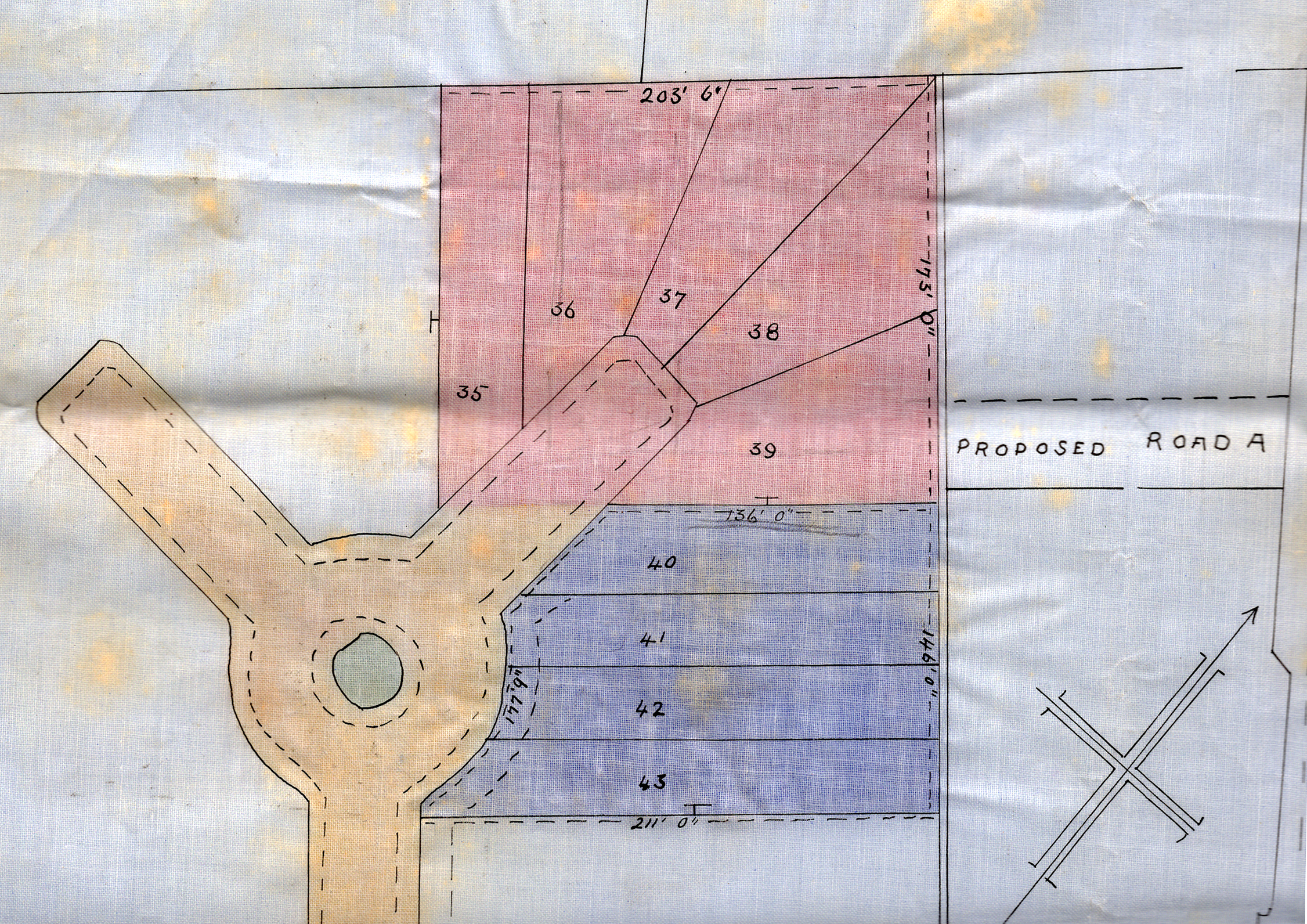
Hollis bought Highworth Estate plots 35 to 39 from Wootten on August 24, 1912
The reconfigured junction
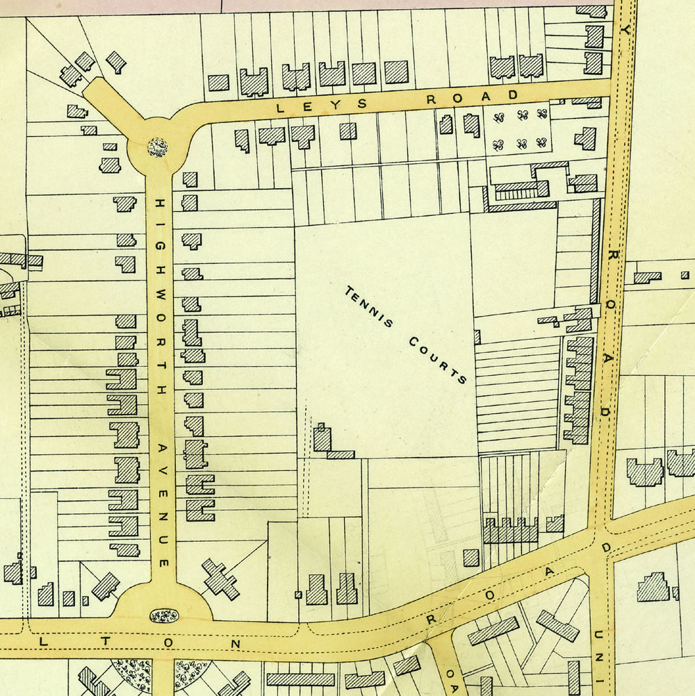
This is part of the map that accompanied the sales particulars for Laundry Farm in 1927. Fifteen years since Wootten and Hollis made their plans, most of Highworth Avenue and Leys Road have been built up, the majority of houses having been constructed after the First World War. With the exception of the shops that are now numbered 1A, the west side of Arbury Road has been developed from Milton Road to Laundry Farm
Building Highworth Avenue
There were some houses built before the First World War depressed the building trade. Electoral lists for 1914-15 comprise ten names, including builder Walter Boyton and Eaden Lilley employee George Heath, whom we encounter in Hurst Park Avenue in 1930. Document bundles tell us that numbers 8 and 10 were built in 1914 and we might assume that the identical pair at 23 and 25 are of the same date. By 1918 there are 22 addresses in the electoral list.