Hurst Park Geology
Hurst Park has a surprisingly diverse geology and we are indebted to neighbours Gary and Christine Gibbons who have shared their research and sources with us. Much that follows is based on their work.
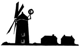
There are, or were, riches beneath our feet or within about half a mile: sand, clay, gravel, and coprolites. The British Geological Survey (BGS) tells us that the bedrock under most of Cambridge and Chesterton is Gault clay, with some outcrops of West Melbury Marly Chalk. It is mostly overlain in Hurst Park by a superficial layer of sand and gravel. This is the Third terrace of the river Cam, also known as the Barnwell terrace. Up in the heights of Orchard Avenue and Hurst Park Avenue we are about 14 metres above sea level, and a reassuring ten metres above the Cam. It is a good place for a windmill. There is a drop of about three metres down to Milton Road.
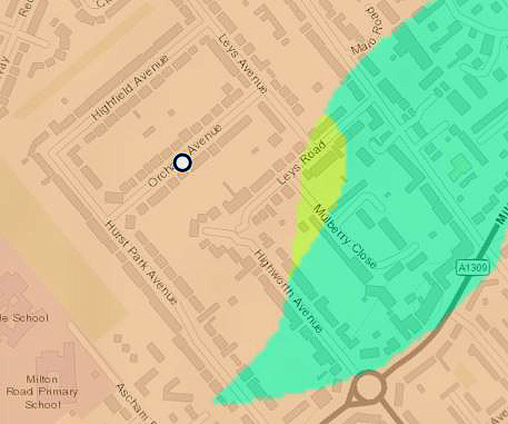
The geology of Hurst Park. The clay (turquoise) is near the surface, the chalk marl (light green) is partly obscured, but it extends as far as Hurst Park Avenue under the overlying sand and gravel (pink) (Permission to use this map has been granted by the British Geological Survey under the Open Government Licence for public sector information).
The BGS’s online map shows that the clay is accessible in a patch that stretches from the bottom of Hurst Park Avenue, across most of Highworth Avenue and Mulberry Close, and beyond Arbury Road to Woodhead Drive. As we discuss below, Mulberry Close was the site of clay digging and brickmaking until early in the twentieth century. However, on top of the clay here, partly covered by the gravel, is an outcrop of chalk marl that runs from the windmill site in Hurst Park Avenue (ie near numbers 18 to 26), across the top of Highworth Avenue and Mulberry Close and along Leys Road. The windmill was built on this outcrop and this is where what Richard Grove called the Cambridgeshire Coprolite Mining Rush briefly touched Hurst Park.
Coprolites: are they dinosaur excrement?
Yes! and No! From Ancient Greek kopros and lithos, excrement and stone, we derive coprolite, coined in 1835 by geologist William Buckland to name the fossilised faeces that he and fossil hunter Mary Anning had found in Gloucestershire. But the hard nodules found in the ground in Cambridgeshire and elsewhere that made some small fortunes 150 years ago are not stony dung. The Bedfordshire Geology Group sum it up nicely in their Coprolites leaflet, pointing out that ‘Our coprolites are not dinosaur dung!’ and continuing:
Real dinosaur dung dating from the Jurassic period is found in Britain, but the coprolites of Bedfordshire, Cambridgeshire, Hertfordshire and Buckinghamshire are nodules of phosphate-rich Cretaceous sediment, often containing fragments of fossils.
The phosphate nodules typically occur at the interface of the Gault clay and the chalk marl. Digging up the nodules to make fertiliser was where the money was. After extraction, trenches were usually filled in and the ground restored to agricultural use, but you can still see open pits in the fen between Horningsea and Lode. There’s also an easily accessible pit in Trumpington Meadows Nature Reserve, just south-west of the motorway. The coprolite rush in Cambridgeshire, in many villages on a long line through Cambridge from south-west to north-east, is well documented by Richard Grove (The Cambridgeshire Coprolite Mining Rush, Oleander Press, 1976) and by Bernard O’Connor in a number of publications.
What is the evidence for coprolite digging in Hurst Park? In July 2018, John Purkis made us welcome in his Highworth Avenue garden, which backs on to the windmill land and which was, for a while at least, owned by Stanley Rose. We discussed the mill and the path that approached it along the side of the garden, and he showed us some old masonry, part of an outbuilding. And he said: ‘You know there was coprolite digging here, don’t you?’ We did not. We were privileged and lucky to meet John then, as he died in December 2018, but it was not until we met Gary and Christine Gibbons that we were able to follow up his lead. They alerted us to page 38 of The Geology of the Neighbourhood of Cambridge by William Henry Penning and Alfred John Jukes-Browne (HMSO, 1881) which tells us:
By the windmill, half a mile N. W. of Chesterton, a small patch of Chalk Marl occurs, from which the coprolites have been extracted, and extends from the top of the clay pits to the back of Rose Cottage, where it underlies the gravel. To the north of Chesterton two other small outliers were found beneath the gravel and the coprolites were all extracted from them in 1873.
We received new information in May 2023. Rob Turner, former Leys Road and Mulberry Close resident, told us that some years ago the building of a house extension had exposed a coprolite pit close to the corner of Leys Road and Leys Avenue.
The Brickworks
The considerable area of the Gault clay means that brick-making was widespread in Cambridgeshire in the nineteenth century and into the twentieth. Near to Cambridge itself, Barnwell was the main area, with four major companies operating around Newmarket Road and Coldhams Lane. The Cambridge Museum of Technology, beautifully refurbished in 2019, has a display about the local brick-making industry.
By comparison, our brick ground looks rather small, but it operated for several decades until the early 1910s. There was also brick-making in New Chesterton, close to the river, where the Arundel Hotel and Alexandra Gardens are now. Coprolites had been found there, too.
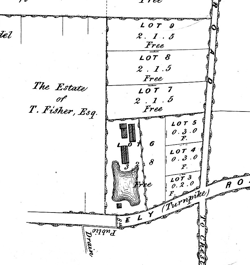
(Cambridge University Library: Maps.PSQ.18.13)
The map above, from particulars for a sale to take place at the Lion Hotel, Petty Cury, Cambridge on July 1, 1852, is our first information about the brickworks, which also appears on the Ordnance Survey maps presented in our section on Chesterton before 1927. Those sales particulars refer to lot 6 as “Brick Ground, facing the Ely Turnpike Road, only part dug, 3.2.8 [ie 3 acres, 2 roods, 8 poles]” and point out that:
N.B.—The Brick-Kiln and all the Sheds and Buildings belong to the Tenant, and the Purchaser of this lot is to pay £100. for the same. The Tenant is also to be allowed until Lady-Day next [March 25, 1853] to clear his Stock.
That sale, by Robert Sparrow’s trustees, is also discussed in our section on Leys Laundry Farm.
A few months later, the brickworks was to be let. The advertisement tells us that Robert Sparrow had run the business:
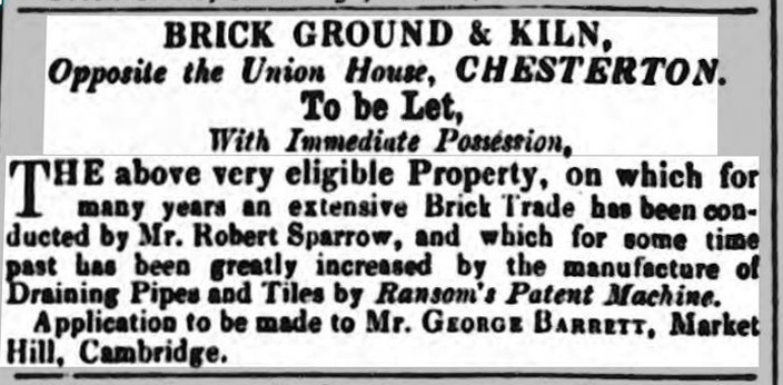
(Cambridge Chronicle and Journal, October 30, 1852)
Information about the brickworks is sparse, but census and street-directory entries show us who was running it over the years. In the 1861 and 1871 censuses Henry Hight is listed as brick-maker in Milton Road. There follows a long association with the Unwin family from Milton.
In 1861, Henry Unwin, then 18, is living at home with his parents: he and and his father Thomas are bricklayers. Ten years later, Henry has married Jane and they are living in Milton. He is still a bricklayer. In the same year, 1871, Thomas Unwin, bricklayer, is listed in Milton Road, adjacent in the census register to Henry Hight, brickmaker. It looks as though Henry Unwin was on the site by 1879: we know from an advertisement (Cambridge Independent Press, July 26, 1879) that he occupied “a piece of arable land, containing 2a. 1r. 5p. (more or less), abutting on the Auberry-road [sic], leading to Histon” when it was put up for sale in August 1879. This must have been Lot 7 on the plan above: it is the right size and the Ordnance Survey of 1885 shows that digging had extended into it.
In our section on Hurst we relate how Josiah Chater frequently visited that house when it was being extended for Mark and Frances Whibley during 1878 and 1879. On May 6, 1879 Chater went “at half past eight to Hurst with Whibley then round to the brickyard and to inspect all his works found things very satisfactory.” Perhaps we can infer that they did not go far and that it was to Unwin that they went. One could re-enact the scene today by walking from Dalegarth at the bottom of Hurst Park Avenue, along Milton Road beyond Highworth Avenue and then by the side of the Viking Fish & Chip Shop to Mulberry Close. Imagine there a scene of clay-digging and kiln-firing that vanished about 110 years ago.
Henry Unwin is still there in the census of 1881, listed in Arbury Road, but it is clearly the same site. He is there in 1891, but in 1901 he and Jane are in George Street with their son and daughter and Henry is now a building contractor. Ten years later, they are still there, aged 68 and 69 and Henry is “builder formerly.”
Back to 1901, and David Covill, 54, Brick Merchant, is listed at the Brickfield, Milton Road with his wife Louisa and their son David, 34. Also there are Jacob Negus, 55, General Labourer, his wife Mary and their five children.
David Covill the younger seems to have been the last of the brickmakers on the site. In the 1911 census he is listed as aged 45, single, living with his widowed mother Louisa (66) at Brickfield Cottage. His personal occupation is “Clay Miner Brick Making” and he is shown as an employer of two people. The 1885 and 1901 Ordnance Survey maps (see our section on Chesterton before 1927) show what looks like a substantial dwelling in the south-west corner of the brickfield site and so we assume that this is Brickfield Cottage.
On the 1901 Ordnance Survey, the diggings have advanced well into the northern part of the site: perhaps twelve years later the useful clay was exhausted. There is no brickfield indicated in Spalding’s 1913 street directory, so it looks as though brickmaking finished even before the First World War greatly reduced building. Gray’s tennis courts, which we will cover in our section on Mulberry Close, were on the site by about 1920.