In the early decades of the 21st century it is not necessarily obvious to residents of the Hurst Park Estate how closely associated our area is with Chesterton village, from which we are divided by Milton Road and Elizabeth Way. But we live in an electoral division that bears the ancient name and in a set of streets that is right in the middle of the old parish. The residential centre, until enclosure in 1840, was around the church and High Street that are landmarks on our way to riverside walks, the Cambridge Museum of Technology or our new railway station. There are still some fine old buildings to be seen. The parish of Chesterton, however, stretched westwards all along the north bank of the river Cam to the castle (where the 19th-century inmates in Cambridge gaol, where Shire Hall is now, were counted in Chesterton censuses). It went beyond Histon Road as far as Huntingdon Road and had boundaries in the north-west with Girton and Impington, and in the north-east with Milton.
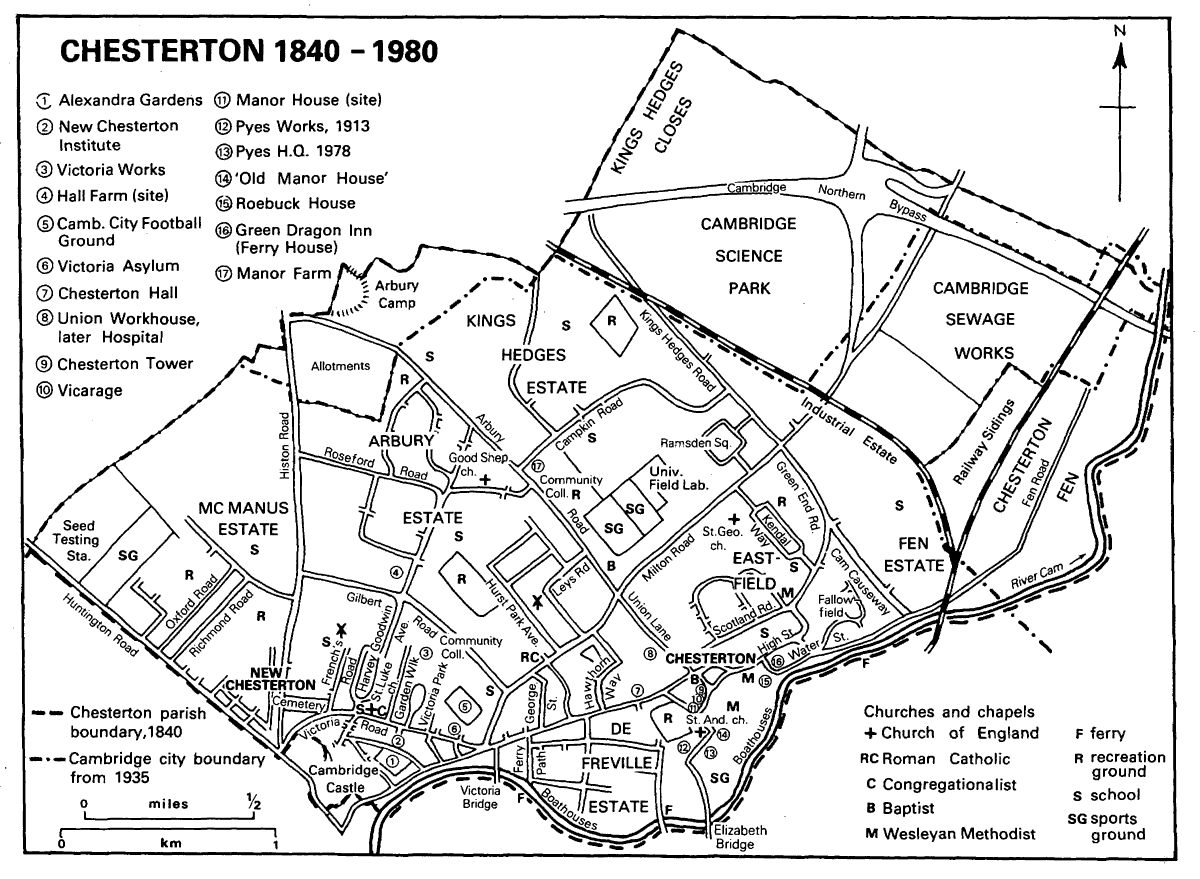 The extent of Chesterton in 1840: from Girton to Milton and from Cutter Ferry to King’s Hedges, with modern features in 1980 (British History Online)
The Romans were in Chesterton: their camp was on Castle Hill by the road to Godmanchester. A villa and burials were found when housing was developed in and near Arbury Road in the 1950s.
Later, British History Online (BHO) tells us that Chesterton was part of an Anglo-Saxon royal vill (a medieval parish or manor) that spanned the river until it was established as a separate burh (a fortified settlement) north of the Cam in the 8th century CE. The built up parts of it did not rejoin Cambridge until 1912, and some of Hurst Park not until 1935. Apart from the village itself, Chesterton was arable land, with three open fields (West, Middle and East) until enclosure in 1840.
Our research in the Cambridgeshire Archives revealed some intriguing correspondence that shows that enclosure might have coincided with a railway that would now be close to Highworth Avenue. On February 13, 1836, solicitors Bignold, Pulley and Moore, acting for the Great Northern Railway Company, wrote to H. R. Evans, Clerk to the Trustees of the Ely Turnpike:
We find today that you are the Clerk of the Trustees of the Ely Trust and observing that this intended Railway crosses the Trust road near Chesterton Town by Claydon Way – May we beg the favour of your writing us a few lines by return of mail stating whether you on behalf of the Trustees will assent or dissent or will be neutral as to the property of the trust to be affected by this Railway.
Two days later Mr Evans replied:
I very much regret my absence from home yesterday which prevented me from answering your letter respecting the Line of the intended Great Northern Railway, which you state as intended to cross the Trust Road near Chesterton Town, by Claydon Way near Cambridge. As I have no means of giving you anything Official as to the Assent or Dissent of the Trustees of the Road to which you allude, which is called the Cambridge and Ely Trust, I can only give it as my individual & private opinion that your best way will be to hear the Trustees as being so far neutral as to admit of their or dissenting to or proposing any Clause for the protection of the Trust in any future Stage on the proceedings of the Bill.
This Great Northern Railway is not the same company as that which was incorporated in 1846 and which built the East Coast Main Line. According to R. B. Fellows (Railways to Cambridge, Actual and Proposed, Oakwood Press, 1948) the route proposed in 1836 ran from Whitechapel in London via Dunmow to Jesus Green in Cambridge and then via Lincoln to York. The Parliamentary Bill for this line failed at its second reading that year and was withdrawn.
In the enclosure of 1840 all the then open land now comprising both sides of Hurst Park Avenue with its gardens, as far north as number 52, including Dalegarth on the one side and 95 to 99 Milton Road and the dental surgery on the other, was awarded to Thomas Riddel who already owned the windmill there. The land on the north-eastern side, up to about number 22, was freehold; the rest (6 acres and 16 perches) was copyhold from the Manor of Chesterton. The northern end of Hurst Park Avenue, Highfield Avenue, Orchard Avenue, Leys Avenue (including all the land to Arbury Road) and Leys Road were then in the possession of Eleanor Sparrow and Robert Sparrow, variously copyhold and freehold. Highworth Avenue is built on three plots (copyhold, freehold and leasehold) occupied in 1840 by Thomas Hall Fisher.
Enclosure and the different types of tenure: freehold, leasehold and copyhold
Enclosure was the process of creating legal property rights to what had been common land and open fields. Freehold land was (and still is) owned absolutely by the owner. Leasehold property is conveyed for a fixed time, which can be quite long, in return for rent. Copyhold land was held from a manor (in this case, the Manor of Chesterton) to which rent was due. It could be bought, sold or enfranchised – that is, turned into freehold land. Copyhold tenure was abolished in 1926.
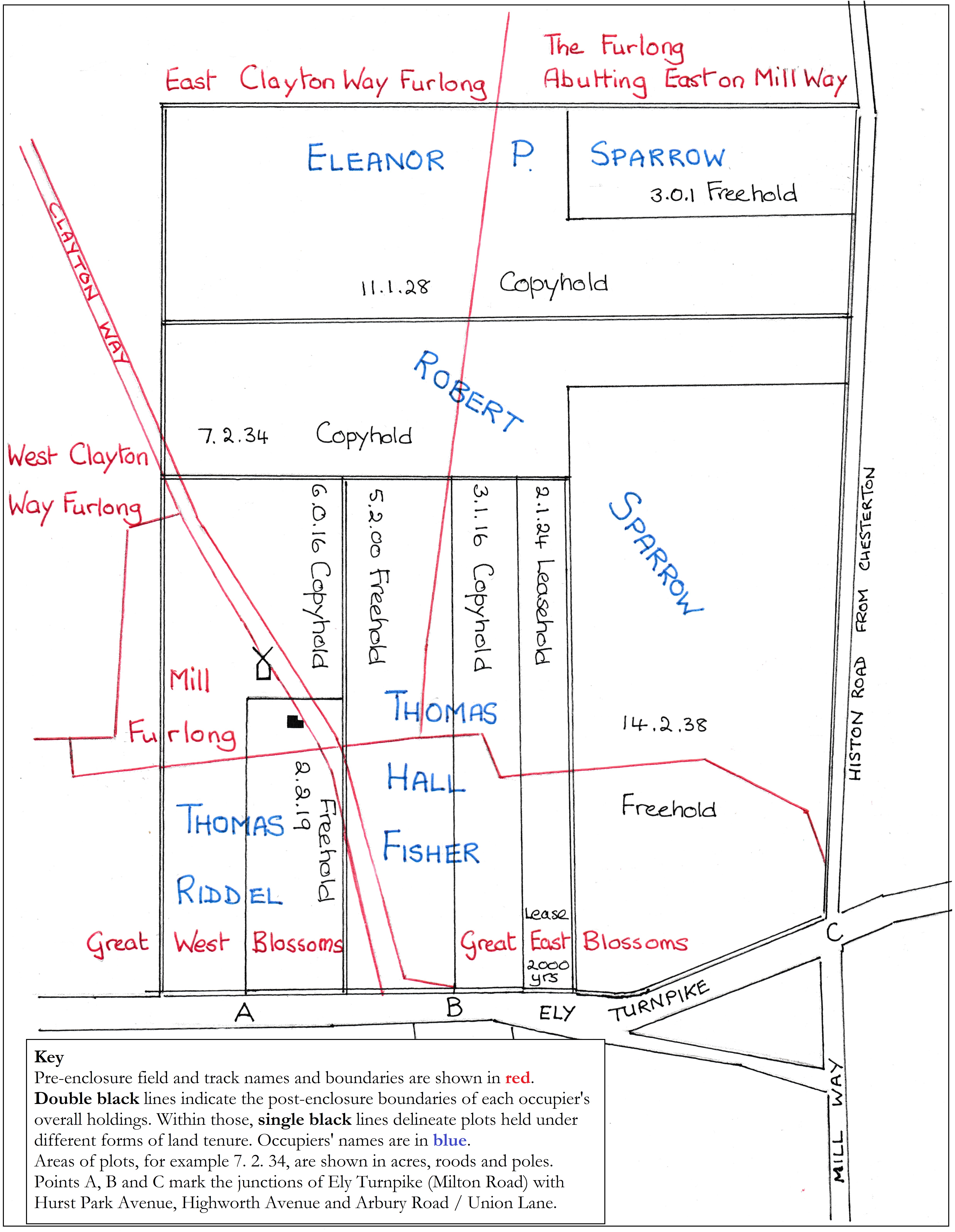
A tracing and adaptation of part of the Chesterton enclosure map of 1839, showing pre-enclosure boundaries and field names in red. The ‘stopped up’ Clayton Way ran from the Ely Turnpike, passing by the mill and its cottage on the land allocated in the enclosure to Thomas Riddel. It crossed the fields to Histon Road. The land allocated to Thomas Hall Fisher was later the location of the Highworth Estate. Eleanor and Robert Sparrow occupy, at the top, all of the land that later comprised Leys Laundry Farm, Leys Road, the brickworks, and the southern end of Arbury Road—referred to here as Histon Road from Chesterton. The original can be viewed in the Map Room at Cambridge University Library.
Enclosure was to bring rapid change: Chesterton’s population doubled from 1,345 in 1841 to 2,480 ten years later. As BHO tells us, this was “largely through settlement in the new suburb”. This refers to the area later known as New Chesterton, that district where the main thoroughfares are Histon Road, Victoria Road, Chesterton Lane and Chesterton Road. Most early development was on the main roads and 240 houses were built there by 1851. However, new developments led to some concerns so, in a move that anticipates attitudes that helped to drive the development of Hurst Park in the 1920s, Trinity and Magdalene Colleges,
… fearing the growth of a ‘low suburb’ with beerhouses and poor cottages, demanded at enclosure the creation of a tree-lined road with a walk by the river, and obtained a road 60 ft wide as far as the junction of the Milton and Chesterton roads, upon which the building line was set back by 30 ft the owners of brick pits there being expensively compensated for their removal.
But development there was and it progressed eastward during the next few decades. However, there was not much building off the main roads until the 1870s and 1880s, around the time when the various occupants of Hurst and the influence they had on the history of Chesterton begin to interest us. Major developments include:
- Chesterton Road: there were 40 dwellings in the 1860s, 114 in 1881, 240 by 1910
- Bermuda Row: built up by 1851
- Albert Street: developed by the 1860s
- Alpha Road: from the 1880s
- French’s Road: by 1877
- Garden Walk: 10 houses by 1881 and 30 by 1910
- Victoria Park: 68 dwellings begun by 1895
East of the junction we know as Mitcham’s Corner were:
- Ferry Path, a terrace of cottages built from 1844
- Springfield Road
- George Street: 25 houses by 1881
- The De Freville Estate: laid out 1891-1893, 220 houses built by 1910
- Kimberley and Pretoria Roads (the Central Building Estate), built between 1903 and 1910
- Chesterton Hall Crescent: proposed in 1884, partly built 1890s to 1910
- The Limes: built after 1885, where St Laurence’s Church is now
- Hurst: built in 1848 as Ely Villa, extended 1878-9
- Houses in Milton Road between Hurst and Highworth Avenue, built by about 1913.
- Highworth Avenue and Leys Road: planned in 1912, partly built up by 1927
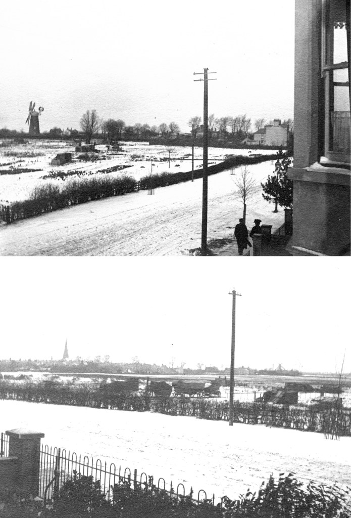
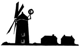
These two photographs, from about 1900, were taken from Milton Road near where the junction with Gilbert Road is now. They appear to have been taken on the same day as one of the pictures we have used in our section on the mill. The upper photo shows the mill, Hurst and the Limes. The lower photo looks the other way towards New Chesterton, where we can see St Luke’s church on the left and French’s Chesterton Mill on the skyline at far right. In the middle distance is a steam traction engine (probably a Burrell, we are told) with a thresher and an elevator (Cambridgeshire Collection, Cambridge Central Library).
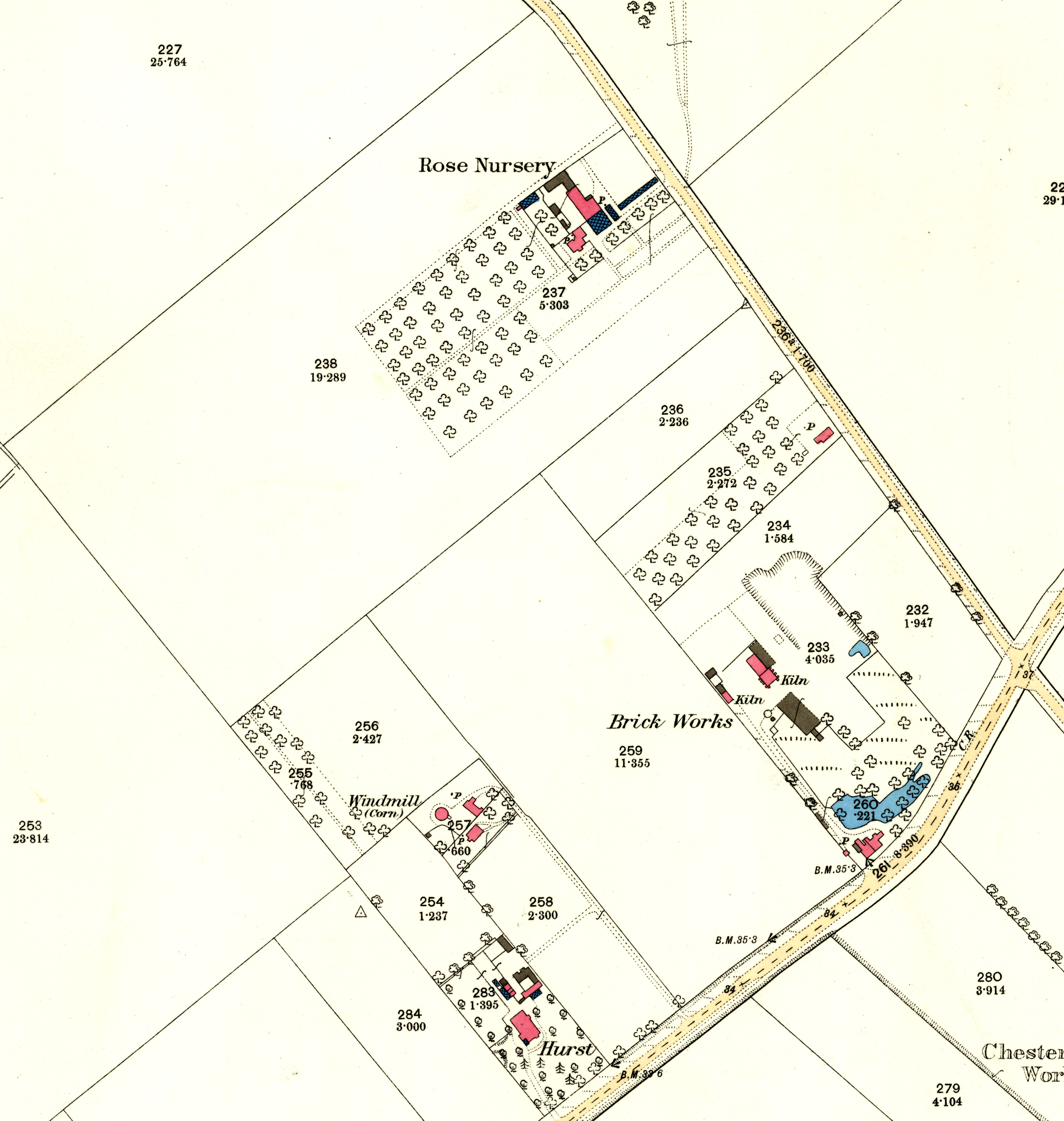
The Ordnance Survey of 1885. Hurst, where the Dalegarth flats are now at the bottom of Hurst Park Avenue, has been built by John Jones in 1848 and extended by Mark and Frances Whibley in 1878-9. William French owns the mill, exactly where 24 Hurst Park Avenue was built in the early 1960s: it was served by the track from Milton Road between plots 258 and 259. John Bester is established in his Rose Nursery, and also has an orchard, on the land where Orchard, Highfield and Leys Avenues were to be built. The brickworks (certainly established by 1852) on the future site of Mulberry Close has its kilns and ponds. The Limes is yet to be built on the plot next to Hurst. Plots 259, 235 and 236 would later become Highworth Avenue and Leys Road. The Arbury Road / Union Lane / Milton Road crossroads is the only obvious feature one can identify in 2022.
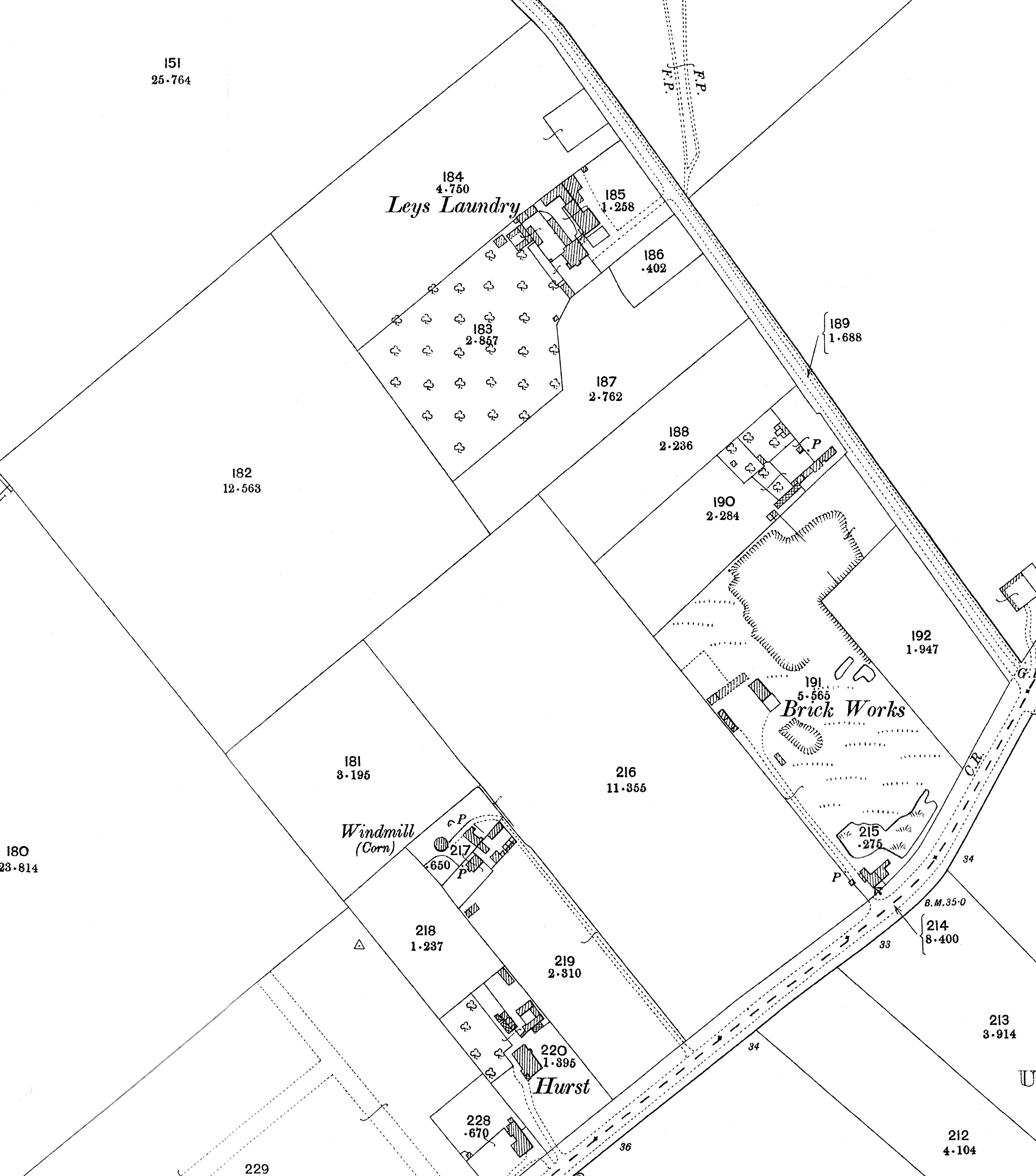
Sixteen years later, the revised Ordnance Survey of 1901 shows the Limes (occupied by Sidney Freeman in 1896) next to Hurst, the mill still functioning, still owned by William French and run by Mr Baker the miller, the clay diggings at the brickworks have expanded, and the Leys School is running farm, laundry and orchard.
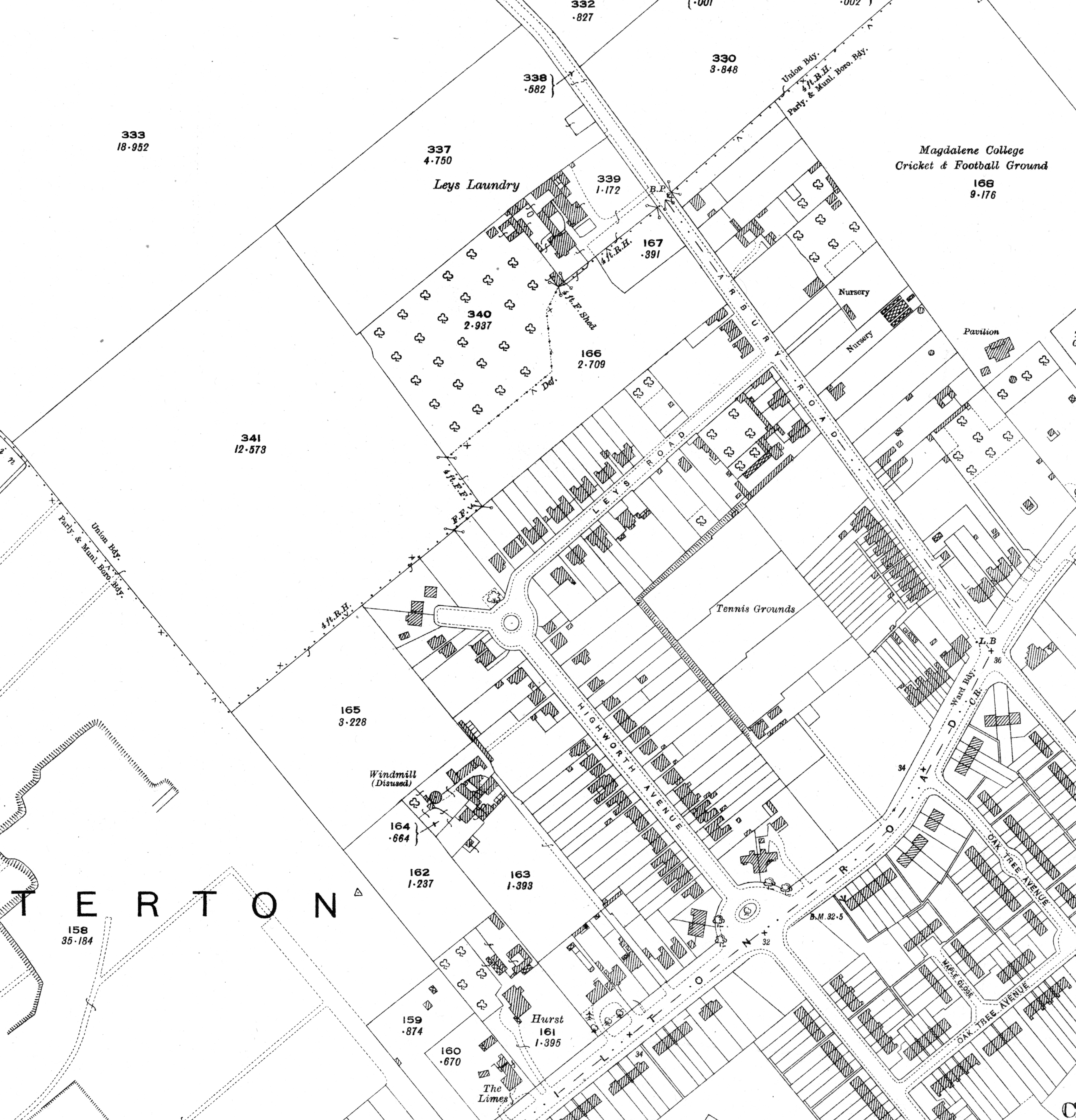
At the time of this 1925 Ordnance Survey, James McCallan Preston is still at Hurst while William Jolley, who succeeded Sidney Freeman in The Limes, died in 1920. Butcher-cum-mill-owner Arthur Rose sold his Milton Road frontage (three large houses stand there) and bequeathed the remainder of his land to his wife Etheldra and son Stanley when he died in 1914. The mill is disused: Stanley uses it as a store and manages a slaughterhouse next to it. Leys School has left the laundry and farm, now run by Charles Alder, Highworth Avenue and Leys Road have been developed, the tennis courts occupy the brickworks site and the shops in Milton Road are yet to be built.
Two years after this last map, in 1927, more change is afoot:
- Hurst and The Limes are still there
- Milton Road is largely built up, but the land to the north is mostly still open
- Stanley Rose the butcher drives his animals up the access lane to his slaughterhouse next to the disused mill, which is still prominent on the slope
- Elizabeth Sell Swann, owner of Leys Laundry Farm, died in 1926
- At Hurst, where the Joneses, Whibleys and Taylors have preceded them, James McCallan Preston and Florence Preston died within a few months of each other in 1927
- Noel Dean lives at 19, Leys Road
- On September 12th, Cambridge Estates Ltd is incorporated and buys Hurst on September 22nd and Leys Laundry Farm on October 14th
- The Hurst Park Estate is born where once grain was grown and milled, fruit trees flourished, pigs rooted, cows were milked, and linen was laundered.